More than Earth Warriors: The Diverse Roles of Geoscientists in Effective Altruism
A global community of and for Effective Geoscientists
tl;dr
We, a small group of geoscientists want to gather a supportive community for knowledge sharing, collaboration, and placing geoscientists EAs in high impact roles.
The use of geospatial data and spatial analysis is underrated. Four out of eight top charities from GiveWell have used geospatial data as part of their research. Particularly, we can have a significant impact in catastrophe resilience.
We would like to advocate for more researchers and effective charities to consider including a geospatial dimension when conducting their studies.
Currently, we will gather on channel role-geoscientists on EA Anywhere slack. Please join us if you are interested.
We listed a few distilled topics that geoscientists EA might be interested in.
Acknowledgement
The completion of this post would not have been possible without the extensive insight, advice, and knowledge shared by the following individuals: Prof. David Denkenberger, Ewelina Hornicka, Petya Kangalova, Leon Mayer, Dr. Kajetan Chrapkiewicz. Any mistakes or oversights in this post are solely my responsibility.
Context and reason for establishment
Figure 1. Both expected impact and personal fit in our career choice reflect a power law.
We want to gather an online community to bring together geoscientists of diverse disciplines. There are two motivations for starting this community. Firstly, we believe that geoscientists and geospatial data can offer value in multiple EA cause areas and intercause research. Secondly, we found that services of current EA infrastructure (e.g. High Impact Professional) did not adequately address the need for our niche speciality and comparative advantage of geoscientists. We want to inform the EA world that we geoscientists exist and our skills and domain expertise can contribute to high impact cause areas. Furthermore, we would like to advocate for more researchers to consider including a geospatial dimension when conducting their studies. Therefore, we would like to bring together geoscientists, current and future, that work in environmental anthropology, epidemiology, remote sensing, geophysics and more. We want to use this community to highlight existing geospatial research happening in the various cause areas, to support each other in interdisciplinary collaboration and place each other in high impact roles.
What is geospatial data?
We use geospatial data everyday, to track our movement, plan our commute. Geospatial data is any information with an addition of locality attached to it, this is usually represented by Longitude and Latitude. Geospatial data can come from many sources, from the satellite images and radar backscatter to submarine bathymetric surveys.
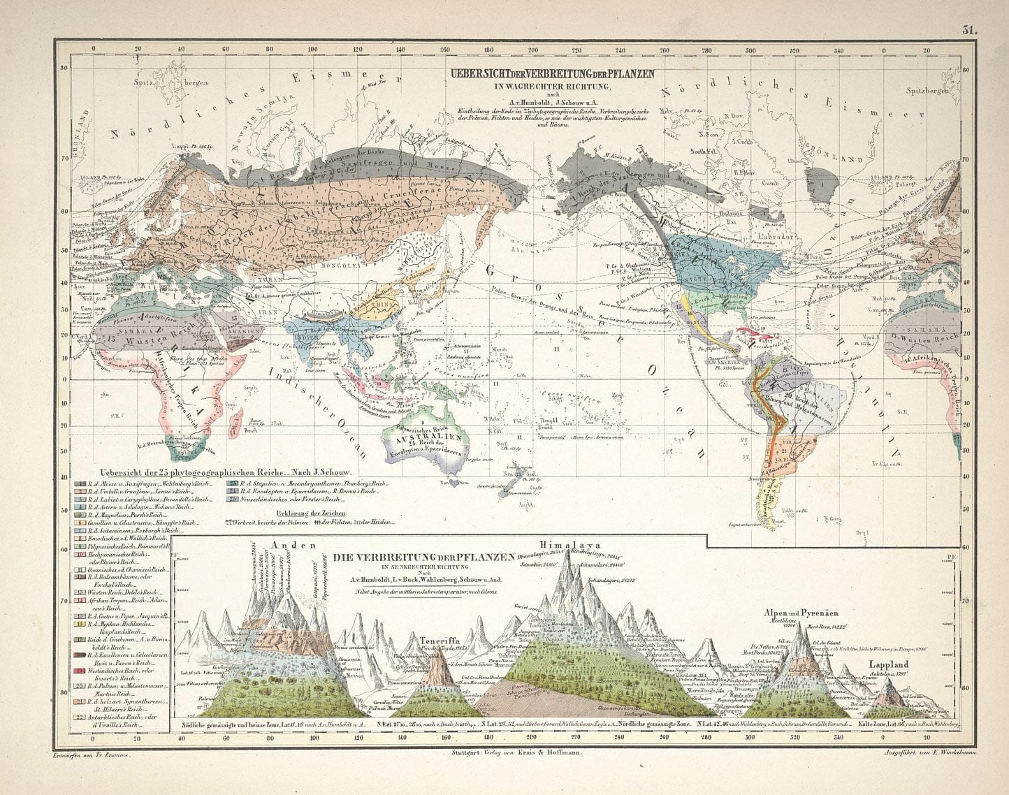
Figure 2. Alexander von Humboldt’s “A Portrait of Nature” in his famous book Der Kosmos (1849).
The development of geospatial science and geospatial data emerged out of necessity. Cartography, the making of maps is the central activity of collecting and distilling geographical knowledge. Initially we made maps for navigation and exploration, then the map became a tool for managing communities, resources, and people, often involuntarily. The map room eventually became the centre of European colonialism in the Age of Discovery (Cresswell T., 2013), and the map room has remained a mainstay of today’s military units’ control and command. Nowadays, geospatial data are used broadly by ecologists and palaeontologists, by sailors and urban planners, by militaries and humanitarian workers alike. While people talk about the temporal component often, the spatial component often goes unnoticed. This post will attempt to demonstrate that the most interesting macro-level and intercause studies will encompass both the spatial and temporal dimensions and of course, beautiful maps.
Review of geospatial studies in near-term cause areas
Four (GiveDirectly, Malaria Consortium, AMF, Unlimited Health (formerly SCI)) out of eight top charities which previously received funding from GiveWell have used geospatial data as part of their research. The following section will give a brief overview per cause areas.
Epidemiology, spatial research in vector-borne tropical diseases
Research in vector-borne tropical diseases such as malaria, trachoma and schistosomiasis have used geospatial data to model studies in prevention, distribution, mitigation, and intervention. Studies have used geo-referenced community and clinic reported data based prevalence to perform prediction and risk-area classification (Cox J., 2012, Cox et al., 2014). More novel models have combined both community data and geophysical characteristics such as proximity to rice farm and land surface temperature to inform intervention measures (Clements et al., 2006, Clements et al., 2008, Clements et al., 2010, Nyandwi et al., 2020).
Examples of relevant research:
Report on work towards a village-based malaria stratification system for Cambodia (Cox J., 2012)
Evaluation of community-based systems for the surveillance of day three-positive Plasmodium falciparum cases in Western Cambodia (Cox et al., 2014)
Bayesian spatial analysis and disease mapping: tools to enhance planning and implementation of a schistosomiasis control programme in Tanzania (Clements et al., 2006)
Mapping the Probability of Schistosomiasis and Associated Uncertainty, West Africa (Clements et al., 2008)
Targeting Trachoma Control through Risk Mapping: The Example of Southern Sudan (Clements et al., 2010)
Modeling schistosomiasis spatial risk dynamics over time in Rwanda using zero-inflated Poisson regression (Nyandwi et al., 2020)
Epidemiology, spatial research in respiratory diseases, biosecurity and pandemic preparedness
Perhaps the most popular or at least the most recognised geospatial application in epidemiology was the near real time COVID dashboard (Figure 3.) from the John Hopkins University Coronavirus Resource Center (Dong et al., 2020). The success and wide adoption of the dashboard tool was the first of its kind to encourage verification of pandemic data across relevant international public health institutions. The efforts have enabled better synthesis between the policy-makers and researchers for pandemic response (Gardner et al., 2020).
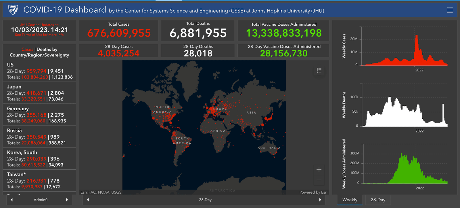
Figure 3. Famous COVID Dashboard by John Hopkins University Coronavirus Resource Center (Dong et al., 2020).
Near real time epidemiological spatial data for COVID-19 was a public engagement success. The publicity and availability of the dashboard have encouraged citizen based pandemic preventative participation. This mobilised citizen science on a community level in anticipation of a local breakout despite asymmetry in local government response (Badr et al., 2020).
Other neglected pandemic preparedness work lies in pathogenic fungi against humans and agriculture. Particularly bioengineered fungi against agriculture are less studied. There is a potential lower barrier of entry for bio- mycoherbicides to be weaponised and deployed. Spatial modelling of spore spread combined with knowledge of spore morphology, microscopy, metagenomics could be valuable, especially as there’s little work done on this.
Spatial research in direct intervention for poverty alleviation
Advancements in higher resolution satellite images, open source geospatial data and relevant geostatistical techniques have proven their use in reconciling locations with data poverty. By interpolating from geospatial proxies, we could gain an understanding of local conditions without the reliance on inadequate or incomplete census statistics (Kuffer et al., 2016, Jean et al., 2016, Quinn et al., 2018, Chi et al., 2021). Studies from Watmough et al. (2019), Berchoux & Hutton (2019) have shown that poverty prediction and variation in rural household wealth can be performed at local level with spatial information. GiveDirectly have previously conducted several such research to inform their Unconditional Cash Transfer program (e.g. Abelson et al., 2014, Varshney et al., 2015., Kirkpatrick K., 2023., Shun & Lummis, 2023).
Examples of relevant research:
Slums from Space—15 Years of Slum Mapping Using Remote Sensing (Kuffer et al., 2016)
Combining satellite imagery and machine learning to predict poverty (Jean et al., 2016)
Humanitarian applications of machine learning with remote-sensing data: review and case study in refugee settlement mapping (Quinn et al., 2018)
Microestimates of wealth for all low- and middle-income countries (Chi et al., 2021)
Socioecologically informed use of remote sensing data to predict rural household poverty (Watmough et al., 2019)
Spatial associations between household and community livelihood capitals in rural territories: An example from the Mahanadi Delta, India (Berchoux & Hutton, 2019)
GiveDirectly research:
Targeting direct cash transfers to the extremely poor (Abelson et al., 2014)
Targeting Villages for Rural Development Using Satellite Image Analysis (Varshney et al., 2015)
Using Algorithms to Deliver Disaster Aid (Kirkpatrick K., 2023)
Cash to flood survivors: 4 things we got right & wrong (Shun & Lummis, 2023)
Climate Change, climate engineering, and frozen pathogens
For many geoscientists in EA, the less neglected cause area of Climate Change is the most apparent choice due to immediate relevance. However, despite considerable investment and regulations, climate change interventions have yet to yield efficient results. The inclusion of climate engineering solutions in the IPCC (2022) AR6 marked a significant attitude shift compared to previous assessment reports. The latest edition outlined the inclusion of climate engineering solutions such as Carbon Dioxide Removal (CDR), Solar Radiation Management (SRM), and discussions from dedicated working groups. However, CDR solutions are still favoured due to the lack of understanding of SRM.
CDR interventions, beyond afforestation, encompass carbon sequestration into biochar, Direct Carbon Capture, and Ocean Fertilisation. While biochar has been widely researched, oceanic fertilisation and other SRMs remain controversial. There has been limited study on active cooling through controlled SO2 injection into the stratosphere and its potential safety for global agriculture (Xia et al., 2014 & Procter et al., 2018).
Climate engineering | Techniques | |
Carbon Dioxide Removal | Biochar A potentially closed-loop highly stable carbon which can be manufactured from any dry waste organic materials. Ocean Fertilisation Untested geoengineering technique designed to increase the uptake of CO2 from the air by phytoplankton, microscopic plants that reside at or near the surface of the ocean. | |
Solar Radiation Management | Stratospheric Aerosol Intervention Injection of reflective aerosol particles directly into the stratosphere or a gas which then converts to aerosols that reflect sunlight. Marine Cloud Brightening Spraying sea salt or other particles in marine clouds, making them more reflective. Ground-Based Albedo Modification Whitening roofs, changes in land use management (e.g., no-till farming, bioengineering to make crop leaves more reflective), desert albedo enhancement, covering glaciers with reflective sheeting. Ocean Albedo Change Increase surface albedo of the ocean (e.g., by creating microbubbles or placing reflective foam on the surface. Cirrus Cloud Thinning Seeding to promote nucleation of cirrus clouds, reducing optical thickness and cloud lifetime to allow more outgoing longwave radiation to escape to space. | |
Table 1. Active and controversial climate engineering techniques (IPCC., 2022).
The SROCC contribution to the IPCC AR6 report has reported that several pathogens have already emerged as a result of the thawing of the permafrost, resulting in an increase of pathogens carried by parasitic nematodes in the Canadian Arctic islands and Fennoscandia regions. The bacteria Erysipelothrix Rhusiopathiae carried by the parasite has been attributed to the >50% decrease in population of Canadian Arctic Muskoxen (IPCC SROCC., 2019). Intercause risk areas associated with climate change and pandemic preparedness from permafrost thaw might be a low-hanging fruit since we can already know the areas experiencing or at higher risk of sustained temperature rise (Gruber S., 2012 & Zhao et al., 2022). This should allow us to start building a repository of vaccines against pathogens and vectors from ground sampling.
EA movement growth in geoethics and involvement in policy
It has been motivating to see the recent efforts in building Effective Altruism in diverse communities (e.g. Longtermism for Muslims). We should consider bridging and bringing EA ideas, especially cause prioritisation and animal advocacy into the discussion of geoethics. This can be done through EA’s participation in organisations such as the IAPG. This is perhaps most applicable to understanding and minimising the impact of resource exploration and extraction on the ecosystem and humans.
On the topic of drastic climate change mitigation measures, we might also want to question when will controversial climate engineering techniques be justified? Will the ethical benefits outweigh the potential permanent changes? How would we compensate for the unforeseen changes, loss and gains (Reynolds J., 2019 & Pamplany et al., 2020)? For instance, societal scepticism and lobbying have caused us to miss the opportunity in economically scaling nuclear energy, one of the cleanest and safest forms of energy. This could have helped us prevent air pollution, reduce the related decrease in Quality-Adjusted Life Years and deaths, and lessen the impact of global warming (OWID., 2022). We might not want to repeat the same mistake with climate engineering solutions. I believe that with careful and methodical considerations, these questions could be answered.
Figure 4. Is there an inflection point where it is actually more ethical for us to take the climate engineering approach (Reynolds J., 2019)?
The one and only geophysical X-risk
Supervolcano and food security
While supervolcano eruptions are less probable than many anthropogenic X-risks, they are not to be underestimated. Three out of five mass extinction events in Earth’s history may have been attributed to supervolcano eruptions and the subsequent climate change effects (Raup & Sepkoski, 1982, Twitchett R., 2006, McElwain & Punyasena, 2007). The magnitude of volcanic eruptions is typically measured on a logarithmic Volcanic Explosivity Index (VEI) scale based on the volume of projectiles. An VEI-0 effusive eruption ejects < 104 m3 (e.g. 2022 Mauna Loa), while an VEI-7 Ultra-Plinian eruption ejects > 100 km3 (e.g. 1815 Tambora) (Newhall & Self, 1982). We have never experienced nor have written record of any VEI-8+ eruptions, although the Toba eruption 74,000 years ago may have been linked to a disputed human genetic bottleneck theory.
In The Precipice, Toby Ord’s corrected response for a VEI-8+ eruption is estimated at 1 in 8000 this century (Ord T., 2020), while smaller but less disruptive eruptions are orders of magnitude more likely. Cumulatively, they have the highest risk in the natural risk category and are similar to the probability of “naturally” arising pandemics (the lowest probability anthropogenic X-risk) (Snyder-Beattie et al., 2019, Mason et al., 2004, Rougier et al., 2018). Fortunately, for smaller magnitude eruptions, the impacts will greatly depend on the location of the expected supervolcano eruption. However, the upper-end of a lower magnitude VEI-7 eruptions (>~500 km3) could still be existential if the unlikely conditions exacerbate the current climate change and Holocene extinction. The 1815 VEI-7 eruption of Tambora volcano has drastically changed the course of history globally (Oppenheimer C., 2003). For a detailed yet approachable introduction, see Cassidy & Mani (2021) forum post.
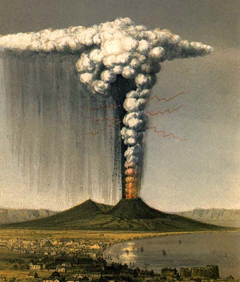
Figure 5. Imagination of a Plinian eruption of Mount Vesuvius at 79 A.D. (the Pompei one) by English geologist George Scrope (1822).
Geoscientists are therefore urgently needed to study the potential fallout of an upper-end VEI-7 eruption (1 in 12 this century) (Rougier et al., 2018) and potential mitigation scenarios for ecosystem collapse, interaction with climate change, and food resilience (Denkenberger & Pearce, 2016).
To illustrate the neglectedness of volcanic research, we can do a basic BOTEC with the US annual budget for mitigating against NASA Asteroid strike compared to the USGS volcanic programs:
The is a calculation that finds the trend of recent funding with bias towards more recent data.
A slight modification on the conventional EMA calculation was made using a geometric series. This adjustment allows for enhanced smoothing and incorporates a geometric discount over a 3-year period to reduce volatility.
Odds of asteroid strike this century = 1 in 1,000,000
Odds of VEI-8+ eruption = 1 in 8,000
EMA (3 years) for 2023 Budget of NASA DART + NEO Program (~ $116.877 million USD) (The Planetary Society, 2019)
Assuming we want to allocate VEI-8+ funding in proportional to the odds ratio of current asteroid deflection funding, accounting for diminishing returns:
Figure 6. When mitigating for highly neglected catastrophic risk, it might warrant a more aggressive initial investment strategy. While Intervention in food resilience scales linearly, volcanic research and volcanic geo-engineering require substantial initial investment. Combining the two functions might approximate to an inverse sigmoid function.
*The annual budget of USGS 5 years National Volcano Early Warning System averages to ~ $11 million USD (USGS, 2022). The total annual budget of UK NERC is ~$503 million USD.
*This also suggests that we should probably be spending at least ~$36.96 billion USD for Unaligned AI with the odds of 1 in 10 this century. (while current funding for AI Safety of 3 years is calculated at ~$52.686 million USD), using McAleese S. (2023) total AI Safety funding as base.
Areas of Interests in catastrophe research
In Luisa Rodriguez (2020) research post on civilisation collapse, she is optimistic that humans are likely to survive a high-magnitude impact catastrophe. I speculate that an upper-end VEI-7 and lower-end VEI-8 eruption would land somewhere between and scenario, erring on if little mitigation were in place. With extensive regional infrastructure damage but global climate change with unexpected consequences, such as more pronounced cooling than expected and uncertainty in extensive stripping of the ozone layer.
: 50% population loss, no infrastructure damage, no climate change (e.g. a limited pandemic)
: 90% population loss, infrastructure damage, and extreme climate change (e.g. nuclear war that caused nuclear winter)
Isolated communities experiencing a cascading series of unfortunate events might experience local extinction if adaptation were inadequate, prolonging civilisation recovery. An historical example is the egregious extinction of the Norse settlements in Greenland. The 1257 A.D. VEI-7 eruption of Samsala volcano caused a decadal cooling of about −1oC in the late mediaeval world. The settlements of the Norse Greenland suffered unrecoverable extinction due to maladaptation despite being very far away from the epicentre and surviving the initial fallout (Dugmore et al., 2007 & Dugmore et al., 2012). A modern day equivalent would be the several months and years post nuclear or volcanic fallout. Investigation into feeding the world when industry and logistics are disrupted will be needed to prevent unrecoverable collapse (Baum et al., 2015 & Denkenberger et al., 2017).
Figure 7. A model of local extinction of the Norse Greenlanders due to maladaptation to changing environments and trade relations (Dugmore et al., 2007).
In the spirit of this, we hope that an interdisciplinary group of geoscientists, where collective knowledge sharing can help each other find our comparative advantages and maximise our impact. Currently, we will just start with a channel role-geoscientists on EA Anywhere slack to gauge the demand for the community. We will adapt appropriately when there’s an appetite for a more structured group.
Few distilled topics from each cause areas that might be interesting to start thinking about:
Supereruption fallout modelling and food resilience
Far-field supereruption modelling:
Global albedo and insolation absorption change
Ocean fertilisation and CO2 drawdown (also a carbon capture and storage candidate)
Stratospheric injection of SO2 and HCI and the meteorological and ozone consequences (this would also inform us about SRM risk and reward)
Food resilience and recovery during the grace period:
R&D investment into farming system for UV resistant and low light crops
Spatial distribution of catastrophic farming system and essential medicine
Supply chain during major logistical and industrial disruption to feed isolated surviving populations
Contribute to ALLFED’s Abrupt Sunlight Reduction Scenarios (ASRSs) plan
Research in volcanic and climatic geo-engineering
Denkenberger & Blair (2018) proposed a speculative range of geo-engineering interventions from altering the properties of magma to releasing the pressure of magma chambers.
Volcanic geo-engineering:
Magma cooling and alteration
Small eruptions and pressure release
Atmospheric containment of eruption materials
Technical climate engineering and environmental impact:
Scaling carbon capture and storage in particular using biochar
Ocean fertilisation and CO2 drawdown
Active cooling from controlled injection of SO2 into the stratosphere
Research in permafrost pathogens, natural and bioengineered fungi against humans and agriculture
Spatial sampling for global distribution of permafrost pathogens and vectors
Modelling the potential spread of known permafrost pathogens that affects humans and agriculture
Research into the spore spread of neglected/bioengineered pathogens such as fungi and mycoherbicides
Building Effective Altruism in geoethics and environmental policies
Animal suffering and resource exploration
The effects of deep-sea mining on ecosystem destruction and animal suffering
Ethics in climate engineering
When is intervention justified, is there an inflection point where neglecting climate engineering actually causes net harm?
If implemented, how may compensation for ecosystem and anthropogenic gains and losses be attributed?
Volunteering for NGO working behind the scenes of other effective charities
NGO such as the Humanitarian OpenStreetMap Team have a history of partnering and delivering projects for public health campaigns against future zoonotic viral diseases, poverty alleviation initiatives and malaria bed nets distribution efforts. EAs are encouraged to strategically engage in projects with recognised high-impact cause areas. A comprehensive list of their past public health work can be found here. Their scalable structure has high potential and could be adaptable to address many of the risks mentioned above.
Contact
Feel free to provide comments, thoughts, and criticism in the comment boxes below, at our slack channel, or contact me at chrischank{at}protonmail{dot}ch. Thank you for reading.
Bibliography
Abelson, B., Varshney, K.R., Sun, J., 2014. Targeting direct cash transfers to the extremely poor, in: Proceedings of the 20th ACM SIGKDD International Conference on Knowledge Discovery and Data Mining, KDD ’14. Association for Computing Machinery, New York, NY, USA, pp. 1563–1572. https://doi.org/10.1145/2623330.2623335
Badr, H.S., Du, H., Marshall, M., Dong, E., Squire, M.M., Gardner, L.M., 2020. Association between mobility patterns and COVID-19 transmission in the USA: a mathematical modelling study. The Lancet Infectious Diseases 20, 1247–1254. https://doi.org/10.1016/S1473-3099(20)30553-3
Baum, S.D., Denkenberger, D.C., Pearce, J.M., Robock, A., Winkler, R., 2015. Resilience to global food supply catastrophes. Environment Systems and Decisions 35, 301–313.
Berchoux, T., Hutton, C.W., 2019. Spatial associations between household and community livelihood capitals in rural territories: An example from the Mahanadi Delta, India. Applied Geography 103, 98–111.
Cassidy, M., Mani, L., n.d. On the assessment of volcanic eruptions as global catastrophic or existential risks.
CEvans, n.d. Taking prioritisation within “EA” seriously.
Chi, G., Fang, H., Chatterjee, S., Blumenstock, J.E., 2022. Microestimates of wealth for all low- and middle-income countries. Proceedings of the National Academy of Sciences 119, e2113658119. https://doi.org/10.1073/pnas.2113658119
Clements, A.C.A., Garba, A., Sacko, M., Touré, S., Dembelé, R., Landouré, A., Bosque-Oliva, E., Gabrielli, A.F., Fenwick, A., 2008. Mapping the Probability of Schistosomiasis and Associated Uncertainty, West Africa. Emerg Infect Dis 14, 1629–1632. https://doi.org/10.3201/eid1410.080366
Clements, A.C.A., Kur, L.W., Gatpan, G., Ngondi, J.M., Emerson, P.M., Lado, M., Sabasio, A., Kolaczinski, J.H., 2010. Targeting Trachoma Control through Risk Mapping: The Example of Southern Sudan. PLoS Negl Trop Dis 4, e799. https://doi.org/10.1371/journal.pntd.0000799
Clements, A.C.A., Lwambo, N.J.S., Blair, L., Nyandindi, U., Kaatano, G., Kinung’hi, S., Webster, J.P., Fenwick, A., Brooker, S., 2006. Bayesian spatial analysis and disease mapping: tools to enhance planning and implementation of a schistosomiasis control programme in Tanzania. Tropical Medicine & International Health 11, 490–503. https://doi.org/10.1111/j.1365-3156.2006.01594.x
Cox, J., n.d. Report on work towards a village-based malaria stratification system for Cambodia.
Cox, J., Dy Soley, L., Bunkea, T., Sovannaroth, S., Soy Ty, K., Ngak, S., Bjorge, S., Ringwald, P., Mellor, S., Sintasath, D., Meek, S., 2014. Evaluation of community-based systems for the surveillance of day three-positive Plasmodium falciparum cases in Western Cambodia. Malaria Journal 13, 282. https://doi.org/10.1186/1475-2875-13-282
Cresswell, T., 2013. Geographic thought: a critical introduction. John Wiley & Sons.
Denkenberger, D., Sandberg, A., Tieman, R.J., Pearce, J.M., 2022. Long term cost-effectiveness of resilient foods for global catastrophes compared to artificial general intelligence safety. International Journal of Disaster Risk Reduction 73, 102798.
Denkenberger, D.C., Blair, R.W., 2018. Interventions that may prevent or mollify supervolcanic eruptions. Futures, Futures of research in catastrophic and existential risk 102, 51–62. https://doi.org/10.1016/j.futures.2018.01.002
Denkenberger, D.C., Cole, D.D., Abdelkhaliq, M., Griswold, M., Hundley, A.B., Pearce, J.M., 2017. Feeding everyone if the sun is obscured and industry is disabled. International Journal of Disaster Risk Reduction 21, 284–290.
Denkenberger, D.C., Pearce, J.M., 2016. Cost-effectiveness of interventions for alternate food to address agricultural catastrophes globally. International Journal of Disaster Risk Science 7, 205–215.
Dong, E., Du, H., Gardner, L., 2020. An interactive web-based dashboard to track COVID-19 in real time. The Lancet Infectious Diseases 20, 533–534. https://doi.org/10.1016/S1473-3099(20)30120-1
Dreier, C., 2019. How NASA’s Planetary Defense Budget Grew By More Than 4000% in 10… [WWW Document]. The Planetary Society. URL https://www.planetary.org/articles/nasas-planetary-defense-budget-growth (accessed 8.28.23).
Dugmore, A.J., Keller, C., McGovern, T.H., 2007. Norse Greenland Settlement: Reflections on Climate Change, Trade, and the Contrasting Fates of Human Settlements in the North Atlantic Islands. Arctic Anthropology 44, 12–36. https://doi.org/10.1353/arc.2011.0038
Dugmore, A.J., McGovern, T.H., Vésteinsson, O., Arneborg, J., Streeter, R., Keller, C., 2012. Cultural adaptation, compounding vulnerabilities and conjunctures in Norse Greenland. Proceedings of the National Academy of Sciences 109, 3658–3663.
Gardner, L., Ratcliff, J., Dong, E., Katz, A., 2021. A need for open public data standards and sharing in light of COVID-19. The Lancet Infectious Diseases 21, e80. https://doi.org/10.1016/S1473-3099(20)30635-6
Gruber, S., 2012. Derivation and analysis of a high-resolution estimate of global permafrost zonation. The Cryosphere 6, 221–233.
Jean, N., Burke, M., Xie, M., Davis, W.M., Lobell, D.B., Ermon, S., 2016. Combining satellite imagery and machine learning to predict poverty. Science 353, 790–794.
Kirkpatrick, K., 2023. Using Algorithms to Deliver Disaster Aid. Commun. ACM 66, 17–19. https://doi.org/10.1145/3591214
Kuffer, M., Pfeffer, K., Sliuzas, R., 2016. Slums from Space—15 Years of Slum Mapping Using Remote Sensing. Remote Sensing 8, 455. https://doi.org/10.3390/rs8060455
Mandeville, C., Cervelli, P.F., Avery, V.F., Wilkins, A., 2022. The Volcano Hazards Program — Strategic science plan for 2022–2026 (No. 1492), Circular. U.S. Geological Survey. https://doi.org/10.3133/cir1492
Mason, B.G., Pyle, D.M., Oppenheimer, C., 2004. The size and frequency of the largest explosive eruptions on Earth. Bull Volcanol 66, 735–748. https://doi.org/10.1007/s00445-004-0355-9
McAleese, S., n.d. An Overview of the AI Safety Funding Situation.
McElwain, J.C., Punyasena, S.W., 2007. Mass extinction events and the plant fossil record. Trends in Ecology & Evolution 22, 548–557. https://doi.org/10.1016/j.tree.2007.09.003
Miner, K.R., D’Andrilli, J., Mackelprang, R., Edwards, A., Malaska, M.J., Waldrop, M.P., Miller, C.E., 2021. Emergent biogeochemical risks from Arctic permafrost degradation. Nat. Clim. Chang. 11, 809–819. https://doi.org/10.1038/s41558-021-01162-y
Newhall, C.G., Self, S., 1982. The volcanic explosivity index (VEI) an estimate of explosive magnitude for historical volcanism. Journal of Geophysical Research: Oceans 87, 1231–1238. https://doi.org/10.1029/JC087iC02p01231
Nyandwi, E., Osei, F.B., Veldkamp, T., Amer, S., 2020. Modeling schistosomiasis spatial risk dynamics over time in Rwanda using zero-inflated Poisson regression. Sci Rep 10, 19276. https://doi.org/10.1038/s41598-020-76288-8
Oppenheimer, C., 2003. Climatic, environmental and human consequences of the largest known historic eruption: Tambora volcano (Indonesia) 1815. Progress in physical geography 27, 230–259.
Ord, T., 2020. The precipice: Existential risk and the future of humanity. Hachette Books.
Pamplany, A., Gordijn, B., Brereton, P., 2020. The Ethics of Geoengineering: A Literature Review. Sci Eng Ethics 26, 3069–3119. https://doi.org/10.1007/s11948-020-00258-6
Pörtner, H.-O., Roberts, D.C., Masson-Delmotte, V., Zhai, P., Tignor, M., Poloczanska, E., Weyer, N.M., 2019. The ocean and cryosphere in a changing climate. IPCC special report on the ocean and cryosphere in a changing climate 1155.
Proctor, J., Hsiang, S., Burney, J., Burke, M., Schlenker, W., 2018. Estimating global agricultural effects of geoengineering using volcanic eruptions. Nature 560, 480–483. https://doi.org/10.1038/s41586-018-0417-3
Quinn, J.A., Nyhan, M.M., Navarro, C., Coluccia, D., Bromley, L., Luengo-Oroz, M., 2018. Humanitarian applications of machine learning with remote-sensing data: review and case study in refugee settlement mapping. Philosophical Transactions of the Royal Society A: Mathematical, Physical and Engineering Sciences 376, 20170363. https://doi.org/10.1098/rsta.2017.0363
Rampino, M.R., Self, S., 1992. Volcanic winter and accelerated glaciation following the Toba super-eruption. Nature 359, 50–52. https://doi.org/10.1038/359050a0
Raup, D.M., Sepkoski, J.J., 1982. Mass Extinctions in the Marine Fossil Record. Science 215, 1501–1503. https://doi.org/10.1126/science.215.4539.1501
Reynolds, J.L., 2019. Solar geoengineering to reduce climate change: a review of governance proposals. Proceedings of the Royal Society A: Mathematical, Physical and Engineering Sciences 475, 20190255. https://doi.org/10.1098/rspa.2019.0255
Ritchie, H., Roser, M., Rosado, P., 2022. Energy. Our World in Data.
Rodriguez, L., n.d. What is the likelihood that civilizational collapse would directly lead to human extinction (within decades)?
Rougier, J., Sparks, R.S.J., Cashman, K.V., Brown, S.K., 2018. The global magnitude–frequency relationship for large explosive volcanic eruptions. Earth and Planetary Science Letters 482, 621–629. https://doi.org/10.1016/j.epsl.2017.11.015
Shukla, P.R., Skea, J., Slade, R., Al Khourdajie, A., van Diemen, R., McCollum, D., Pathak, M., Some, S., Vyas, P., Fradera, R., Belkacemi, M., Hasija, A., Lisboa, G., Luz, S., Malley, J. (Eds.), 2022. Climate Change 2022: Impacts, Adaptation and Vulnerability. Contribution of Working Group III to the Sixth Assessment Report of the Intergovernmental Panel on Climate Change. https://doi.org/10.1017/9781009157926
Shun, M., Lumis, V., 2023. Cash to flood survivors: 4 things we got right & wrong [WWW Document]. GiveDirectly. URL https://www.givedirectly.org/flood-pilots/ (accessed 8.28.23).
Snyder-Beattie, A.E., Ord, T., Bonsall, M.B., 2019. An upper bound for the background rate of human extinction. Sci Rep 9, 11054. https://doi.org/10.1038/s41598-019-47540-7
Twitchett, R.J., 2006. The palaeoclimatology, palaeoecology and palaeoenvironmental analysis of mass extinction events. Palaeogeography, Palaeoclimatology, Palaeoecology 232, 190–213. https://doi.org/10.1016/j.palaeo.2005.05.019
Varshney, K.R., Chen, G.H., Abelson, B., Nowocin, K., Sakhrani, V., Xu, L., Spatocco, B.L., 2015. Targeting Villages for Rural Development Using Satellite Image Analysis. Big Data 3, 41–53. https://doi.org/10.1089/big.2014.0061
Watmough, G.R., Marcinko, C.L.J., Sullivan, C., Tschirhart, K., Mutuo, P.K., Palm, C.A., Svenning, J.-C., 2019. Socioecologically informed use of remote sensing data to predict rural household poverty. Proceedings of the National Academy of Sciences 116, 1213–1218. https://doi.org/10.1073/pnas.1812969116
Xia, L., Robock, A., Cole, J., Curry, C.L., Ji, D., Jones, A., Kravitz, B., Moore, J.C., Muri, H., Niemeier, U., Singh, B., Tilmes, S., Watanabe, S., Yoon, J.-H., 2014. Solar radiation management impacts on agriculture in China: A case study in the Geoengineering Model Intercomparison Project (GeoMIP). Journal of Geophysical Research: Atmospheres 119, 8695–8711. https://doi.org/10.1002/2013JD020630
Zhao, S., Cheng, W., Yuan, Y., Fan, Z., Zhang, J., Zhou, C., 2022. Global permafrost simulation and prediction from 2010 to 2100 under different climate scenarios. Environmental Modelling & Software 149, 105307. https://doi.org/10.1016/j.envsoft.2022.105307
- ^
- ^
Discounting the risk ratio with was done because merely scaling by is, although logical, would not account for diminishing return. A more conservative calculation would be , however, this might be too conservative.
- ^
Above calculations are already very conservative. Denkenberger et al. (2022) have presented a more sophisticated modelling to justify for even higher investment and ROI.
I found this piece a little hard to parse, so can I ask some questions?
It seems the main conclusion you have is that geospacial data is really important and maybe underrated in EA? And the we should focus on it being more accurate?
Thanks for your work writing this piece.
Hi Nathan, thanks for reading. The point of this post was really to address 2 problems:
1. It is generally really difficult to find geospatial scientists (Earth Observation, GIS...) and Earth System Scientists (Geophysicist, Volcanologist...) people in EA. We are a minority here. We get really excited when we meet each other. We want to gather a community and say we can contribute.
2. Geospatial data is very useful in many aspect of our cause areas, hence the breadth of case studies listed above, from neartermist to semi-longtermist (particularly supervolcano impact). While EA as a community don’t seem to attract a lot of geoscientists in general (perhaps it should). Current career advice seem to always err on the side of take your quantitative skills and go work in consulting or finance (which was what I did too). We know that geospatial data and our niche skillsets can contribute, therefore, this post is also a chance to inform the rest of EAs the current geospatial research happening. Think about geospatial data and spatial analysis as a “common language” between an epidemiologist and a volcanologist. Perhaps direct cross-pollination might not happen, but a platform for skill-sharing would be useful.
So yes, geospatial research is underrated. I am not arguing more people should become a satellite image analyst, more advocating for if you work in global health or poverty alleviation already, perhaps also pay more attention to the geospatial aspect of it. Additionally, we could be a platform that perhaps provide geospatial research support if this community gain traction.
Hope this clarifies,
Chris
Thanks. Can I suggest some slight changes to the tl dr at the start
Tl;dr
I am a geospacial scientist who wants to connect with other geospacial scientist EAs
I think that since many EA orgs already use geospacial data, this is perhaps underrated (examples below)
Currently, we will gather on channel role-geoscientists on EA Anywhere slack. so if you are interested, check it out
We listed a few distilled topics that geoscientists EA might be interested in.
Hi Christopher and Ewelina, thanks for this post, it’s nice to see geoscientists in EA and advocating for the skillset that Geoscientists pose and you’re right that it already plays a role in many of the EA causes. I may use this these examples to share with my undergrads!
I like the estimation calculation you do to equate the money proportional to planetary defense weighted to its odds. However you seem to use the Ord value of 1 in 8000 per century of a Supereruption. But Toby is talking here of a super eruption the size of Toba eruption which is 5000 km3 in volume. To be registered as a super eruption it’s 1000km3 and the estimated probability of this supereruption volume is 1 in 170 per century (Rougier et al 2017). So it would be interesting to re-hash your model with this value instead- I would be interested to see how it compares with our expected value estimation in our paper here: https://www.nature.com/articles/d41586-022-02177-x “The financial losses resulting from a large-magnitude eruption are estimated to be in the multi-trillions8, roughly comparable to those of the pandemic. Given the estimated recurrence rate for a magnitude-7 event, this equates to more than US$1 billion per year.”
Another point to make here is the volume of the eruption is not necesarrily proportion to its impact, for the global climate-impacts sulfur content is a better metric, and sometimes there is an asymmetry between eruption volume (or VEI) and climatic impact (Schmidt and Black, 2022). This is where the ice-core record is a good proxy.
I should also add that we have been trying to attain funding from EA sources to conduct research on impacts from large eruptions on society for a few years (e.g. quantifying lives lost and mitigation strategies), but despite the neglectedness, tractability and importance of this risk, the funders have not been interested to date.
To end on a better note, I’d be happy to join your slack group- thanks for creating it.
P.S. We have a paper on the Ethics of Volcano Geoengineering coming out next month
Thanks for reading Mike.
With an odd of 1 in 170, that will result in ~$8.964 billion USD (Note that this number and the above numbers are also yearly investment). Not exactly a trillion just yet. The report states that $428.51 trillion over 5-years loss should be considered, if the mean: $85.702 trillion USD GDP loss could be averted by 8.964 billion yearly, this will result in a cost-effectiveness ratio of roughly 9,600:1.
I.e. $1 USD in investment would save ~$9,600 USD in potential economic loss yearly. Although, given my modest understanding of insurance products, if a supereruption does occur, I suspect that payout to loss will have a P<1 chance of actually materialising. I will need to do more research on this to provide a better answer...